Showing posts with label Stage 5. Show all posts

Croy to Milngavie

1 August 2010 - CROY to Milngavie

Distance - 18.2 miles
Weather - Changeable


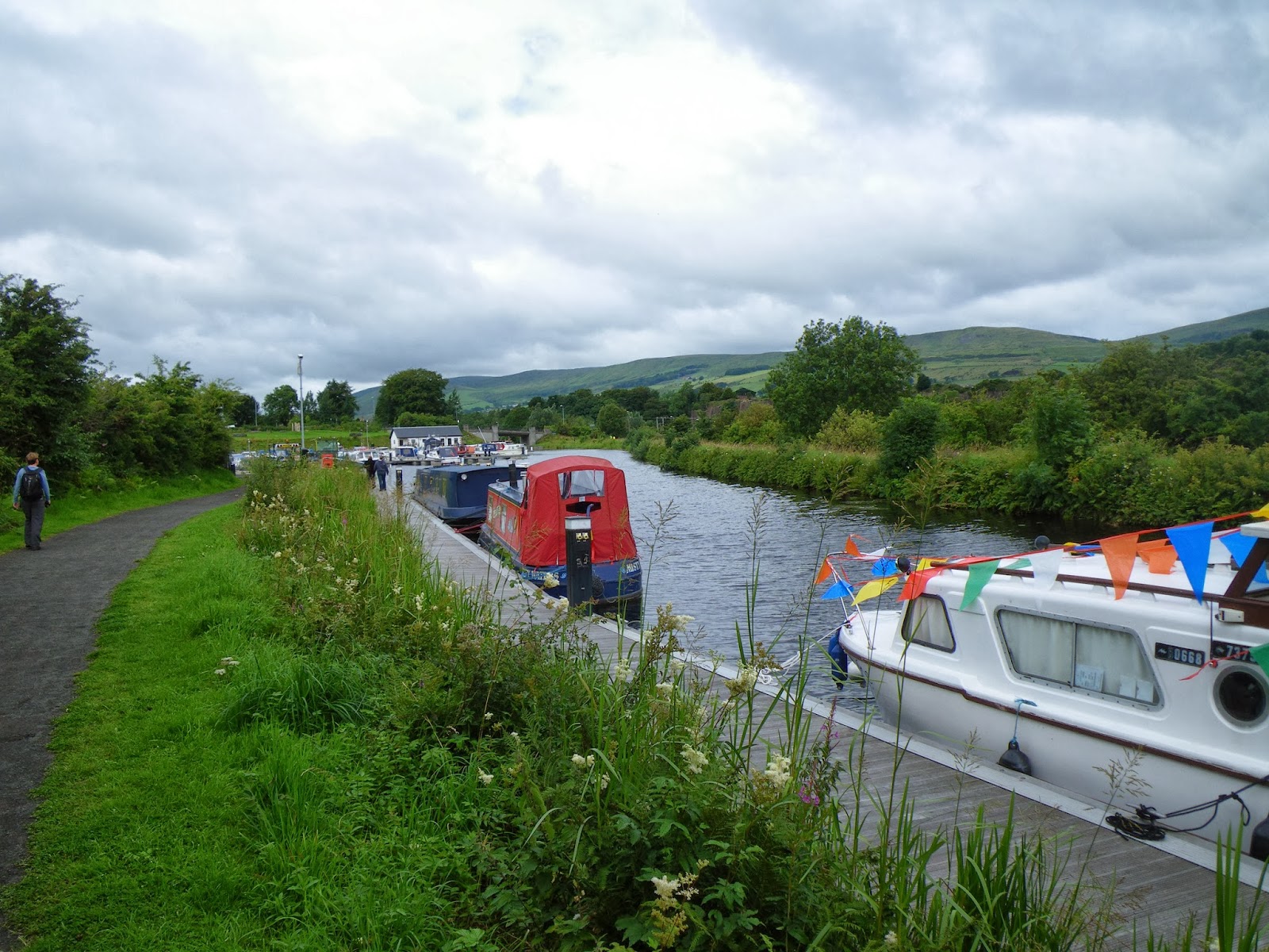
Forth & Clyde Canal Near Croy
To complete this section of the walk we took the train
Marker By Hillhead Bridge
from Stirling to Croy. We followed the road for a short while until we found a footpath that took us down to the canal, which saved us from walking on the B802 for any great distance. We then meandered along the Forth & Clyde canal passing through Auchinstarry, the outskits of Twechar, along to Kirkintilloch. At Hillhead Bridge in Kirkintilloch we left the canal to continue its journey to Glasgow and the Clyde at Bowling, whilst we took the Strathblane Railway Walkway which runs beside Glazert Water, which I believe is a tributary of the River Kelvin.


Strathblane Railway Walkway
It was quite pretty walking along this section of
Dunglass
disused railway line - a lot of it was through woodland and there were views of the Campsie Fells. The track surface was quite varied and it made a change from the flat and often muddy canal tow path. Just before we reached Strathblane we passed the little rocky hill of Dunglass, which was quite a contrast after the Campsies.


Milngavie Station
The logical thing to do at Strathblane would have been to continue onto Netherton to take a footpath joining up with the West Highland Way, but we needed to get some transport home and there isn't much after Milngavie. So instead, we walked up to an unclassified road that went past Mugdock Country Park and Mugdock reservoir and into Milngavie where we caught the train into Glasgow, then a train up to Stirling. Milngavie is the start of the West Highland Way and we planned to spend a fortnight's holiday walking that and the Great Glen Way to take us further North and our ultimate destination. 

Falkirk to Croy

26 September 2010 - FalKIRK to Croy

Distance - 12.2 miles
Weather - Sunny


To complete this section of the LEJOG we drove from Stirling to Falkirk High station. After
parking the car we made our way to the canal tow path. There were a lot of people gathered by the canal, several with some serious camera equipment. We gradually learned that this was the tenth anniversary of the reopening of the Union Canal and that there was a large flotilla of canal boats undertaking the journey from Edinburgh to Bowling. There were also special events happening all along the canal today. We hung around for a while, but learned that the boats had stopped off at Linlithgow (probably at that nice cafe by the canal basin we visited) and it would be some time before they made an appearance at Falkirk. So we decided to start walking and see if they caught up with us.

Deep Lock Near Falkirk High
We wandered along the tow path, up to a very deep
Santa's Canal-side Grotto
lock, where we met a member of the British Waterways team, who chatted about the canal and the effort it had taken to re-open the canal. She also chuckled when we asked about the flotilla, apparently it was more of a jaunt that a project and the schedule was quite variable! There was no telling when they would get to Falkirk! So we trundled on, past Santa's grotto, which looked a bit incongruous framed by the bright blue sky towards Rough Castle Tunnel.

Rough Castle Tunnel
Inside The Top Of The Falkirk Wheel
Rough Castle Tunnel is another of these dark, wet and dripping tunnels, but with a difference - this one has the Falkirk Wheel at the end! There were once a number of locks joining the
Falkirk Wheel
Union Canal and Forth & Clyde canal together, but they were demolished when the canal fell into disuse - the Falkirk Wheel was built as a means of reconnecting the two canals. 
I really think this structure speaks volumes about British engineering and I love the fact that it's practically on my doorstep. There are lots of quirky facts regarding the wheel, my favourite is how efficient it is. The tow path continues into the top of the wheel itself, but as per our rules regarding taking lifts and ferries, we didn't take the boat trip that day, but walked down to the Visitor's Centre. There were even more distractions here, with a mini fete taking place - including a display of hawks and owls. After a nosy around and the obligatory ice cream, we continued our walk, now on the tow path of the Forth & Clyde canal.
Lift Bridge At Bonnybridge

Once the tow path had passed the Falkirk Wheel car park, the crowds thinned and we had it practically to ourselves for the rest of the way. We made our way through Bonnybridge, where the road can be lifted to allow boats to pass. We carried on up to Haggs, passing by the construction site of the upgrade of the A80 to the M80, and under another of those new Millenium bridges to cross beneath the M80 itself. 


Quarry Workings At Croy Hill
The most "interesting" part of the day was when we decided to leave the canal and make our way to Croy station, to catch the train back to Falkirk. The map clearly stated that there was a track leading all the way to the station and we decided to take this, rather than walk along to the B802 (which is a bit of a ratrun). Everything started off OK, there was a really big vehicle track, which later narrowed to a footpath, then disappeared. Bearing in mind that this whole area is an old quarry, we cautiously made our way along the remaining few hundred metres to the station. Inevitably, we saw the train go past, just as we were about five minutes away from the station and had to wait an hour until the next one to Falkirk High!


Linlithgow to Falkirk

17 July 2010 - LINLITHGOW To Falkirk

Distance - 9.8 miles
Weather - Sunny


To get to the start of this section of the walk, we drove to Falkirk, then caught a train from Falkirk High to Linlithgow. As it was a very short stretch and all on level tow paths, I did a foolish thing. I decided I would wear an old pair of trainers, rather than my walking boots. Alistair also did a very foolish thing. He decided not to pack a medical kit. As I'll discuss later, both of these decisions turned out to be a bit silly.

Canal Just Past Linlithgow
We started off our walk by leaving the station and
Rural Scenes
making our way to the canal tow path - or more specifically, the very nice cafe by the canal, where we enjoyed some refreshment before we set off. Once we had left Linlithgow behind us, we found ourselves walking alternatively alongside trees or fields. The canal here was in a much more rural setting than it had been for the previous stretch. It also seemed this whole section was much favoured by cyclists, runners and dog walkers, as we spent a considerable amount of time getting out of their way.

We had only walked about four miles before I discovered my trainers were rubbing my heels a bit, so I asked Alistair for a couple of Compeed. It was at this point he confessed that he hadn't brought the medical kit. I then did the worst thing possible and decided to ignore the chafing. My heels were quite sore as we approached Polmont, where the tow path became a bit more urban - especially as we passed Polmont Young Offenders Institution. Alistair asked if I'd like to stop at Polmont station and just catch the train back to Falkirk, but I stubbornly decided to carry on.

About a mile on from Polmont, I was rolling down my socks and fashioning them into buffers to stop the rubbing. It didn't really work and by the time I reached the 631 metre long tunnel, just before Falkirk High station, they were red raw and bleeding. Incidentally, their is no need for a  tunnel at this point, it was dug purely to stop a certain rich industrialist, William Forbes, from seeing the canal from his estate. It was quite dark and wet in the tunnel and I was grateful for the handrail and railing put there to stop walkers from falling into it. I was even more grateful when we got to the car and the day's walking was concluded.

It's ironic that in all the miles we walked during the LEJOG, that section was the one which gave me the most painful blisters - it demonstrates what can happen when you omit to take adequate care!

Kirknewton to Linlithgow

07 AUGUST 2010 - KIRKNEWTON TO LINLITHGOW

Distance - 15.1 miles
Weather - Overcast

For this segment of the LEJOG we initially caught the train from Stirling to
Visitor Centre, A&C Country Park
Edinburgh Haymarket, then took a subsequent train out to Kirknewton. We left Kirknewton station and walked into East Calder and through the Almondell and Calder Country Park. This ensured that not only could we use public transport (much cheaper than using two cars) but, more importantly, there were no gaps in our LEJOG route.

Lin Mill Aqueduct
As mentioned in a previous blog, the journey through the Almondell & Calder Country Park is very pretty. Our route used a footpath running beside the River Almond, which we followed to West Clifton and afterwards we followed an artificial feeder channel to a confluence of waterways around the Union Canal. Just before we met the canal we got a good view of the Lin Mill Aqueduct. At this point we chose to follow the wrong side of the canal over the aqueduct and had to retrace our steps so that we had a tow path available once we had actually crossed the aqueduct. Neither Al nor I were brave or stupid enough to jump over, regardless of how narrow the distance seemed!

New M8 Motorway Bridge
The Union Canal was opened in 1822 to link Edinburgh and Glasgow, but never really got much use as the railways provided a faster alternative in the 1840s. It was closed for ages, but was reopened in 2000 following a grant from the National Lottery Millennium Fund. This included the construction of a new bridge for the M8 motorway south of Broxburn, which we later passed. It didn't look as pretty as the Victorian architecture, but at least someone had tried to make the bridge look a bit more than a slab of concrete. The route here wasn't all that scenic and some people have commented that the stretch of canal between bridges 23 and 27, through the housing estates of Broxburn, is possibly slightly more risky than Cross Fell in poor weather! Luckily we didn't encounter any problems, although there were plenty of empty Tennents Super Lager cans lying around!

Bings At Niddry
Interesting Marker
Further along the track we passed by some bings at Niddry - these are spoil heaps from shale workings. The bings all have a flat top to ensure there are no mud slides. Apparently the shale bings of Lothian are the only examples of a shale bing in the UK and are important sites for biodiversity. This stretch of the LEJOG seemed steeped in industrial archaeology, as later we passed an interesting marker (although we never found out what this was about).

Distant View Of Linlithgow
We continued following the tow path, which first passed through some woodland, then meandered through fields (often running parallel to its nemesis the railway) for the rest of the way into the ancient and royal town of Linlithgow, with its palace and strange church steeple. There are frequent reports of UFO sightings around Linlithgow and if they are actual UFOs and not just aircraft from nearby Edinburgh airport, then I think the church steeple must be the thing that attracts them! We left the canal at Linlithgow and made our way to the station to catch a train back to Stirling.


West Linton to Almondell & Calderwood Country Park

14 August 2010 - West Linton to Almondell & Calderwood Country Park

Distance - 14.9 miles
Weather - Overcast


After parking one car at the Almondell & Calderwood Country Park, we drove the other over to our starting place at West Linton. It was a nice place with a Post Office and Co-operative providing the opportunity to buy some provisions for our walk.

Buildings near Baddinsgill Farm
This chunk of the LEJOG was taking us across some of the Pentland Hills to the outskirts of Livingston. We started from the town centre, crossing the A702 by a pub called the Gordon Arms and then followed a little lane called The Loan - which had posh looking houses in large plots on each side of it. Just past a golf Club House, we took a right turn to join Agricola's Roman road. This was a little bit better underfoot than the Roman road, Dere Street, which we had met in the Borders. After a left turn at Stonypath Farm, we made our way round the bottom of Faw Mount, which was followed by a good deal of faffing around over footbridges and some wet ground until we reached the road at Baddinsgill Farm. Looking at the map now, I'm not sure why we did all this, as if we'd have kept straight on at the Club House we could have got to exactly the same place on a perfectly adequate lane! Maybe we didn't want to miss Faw Mount!

Highland Cattle on the Thieves Road
A little way past the farm, we caught glimpses of Baddinsgill Reservoir on our right; however, we continued on round the base of Muckle Knock hill. After this we joined a track called the "Thieves Road" and followed this, carefully avoiding the very large Highland cattle that were grazing along it - usually in the most inconvenient places!


View down to Harperigg Reservoir
We kept on the Thieves Road right up to the Cauld Stane Slap. The Thieves Road is an old drover's road and the name possibly reflects what Victorian society thought about this group of people. It was used to move cattle from Falkirk to Peebles. Later, Victorians used the track to travel between the railway stations at West Linton and Kirknewton. A "slap" is a pass and on anything but a summer's day, I bet it's a remote and bleak place. After the slap there was a good view of the Harperigg Reservoir and the path started to descend. The area around Harperigg is a nature reserve and had a lovely new wooden bridge over one of the streams - so new, it still had sawdust around it! There were also some great views of the Forth bridges, Arthur's Seat and Edinburgh from here.

The Thieves Road ended when it met the A70 at Little Vantage. The End To End Trail book suggested that we continue over Corston Hill, which might have been only 348 meters high, but was a bit of a challenge - first to find a way over the barbed wire fence and then a way through the boggy and uneven ground to the top. The views were quite nice up here and we descended following some old boundary stones down to an unclassified road that led past Selm Muir Wood. We followed this road all the way to East Calder (pronounced "codder") and then made our way to the Almondell & Calder Country Park We had of course parked the car at the most distant of car parks, but it was no hardship to walk through the pretty grounds.

Peebles to West Linton

4 June 2011 - Peebles to West Linton

Distance - 13.7 miles
Weather - Overcast


Today was achieved using two cars, leaving one in West Linton, then
Looking back to Peebles
driving the other one to the car park in Peebles next to the Tweed. Peebles is quite a nice little town, although a little less picturesque and a little bit busier than either Jedburgh or Melrose. The town itself was established by Royal Charter (King David II) in 1367 and has all the amenities a walker could require - bank machines, food shops and loos!

Border hills near Jedderfield
For the first half of our walk we followed the riverside path, beside the River Tweed, as far as Neidpath Castle. Then left the Tweed for the last time to cross the A72 and walk along a footpath past Jedderfield Farm and through Jedderfield Plantation. We then stuck to a valley path between Hamilton Hill and South Hill Head, passing through Upper Kidston Farm and contouring round the bottom of White Meldon hill. The End to End trail suggests you traipse all the way to the top of White Meldon (and at 427m it's not that much of a slog), but (and I'm going to be controversial here) the view from the top is much the same as the view from any other Border hill, so we didn't think it worth the effort.

Clearly not the Ayrshire town!
After crossing a little unclassified lane, we made our way up a farm track to a farm called Stewarton. We felt we needed to take a picture at this point, as Alistair's family live in the Ayrshire town of Stewarton, so it was a bit of a joke for us (albeit not that funny). From Stewarton, there was a climb up through pine forest to Courhope then down to Flemington Burn. After which, we skirted round Green Knowe and walked between Drum Maw and Hag Law until we joined the A701 at Damside.

The twenty minute walk along the A701 wasn't that inspiring, there were lots of cars, the drivers of which were clearly not expecting there to be any walkers on the road. In fact we caught up with a big group of them, all returning to West Linton. Al & I didn't want to be rude, so walked with them for a while, but couldn't really walk at their pace, so we left them halfway along the B7059, which we followed until we got back to the car on the outskirts of West Linton. I'd ended up having to park my car on a grass verge quite a way from the centre of town, as there had been some sort of fete or agricultural fair and the place had been absolutely packed. Even when we returened, there were still quite a few people, horse riders and dogs all milling about the streets.


Traquair to Peebles

15 May 2011 - Traquair to Peebles

Distance - 7.25 miles
Weather - Sunny


We undertook this stretch of the LEJOG on a Sunday one weekend, although it added just 7.25 miles to our overall progress, we actually walked to Traquair and back again, making it a respectable 14.5 mile day's walk. The reason for such a compact section was that we didn't want to combine Traquair with the next stage as it would be too long  (Peebles to West Linton is 13.7 miles, meaning a 21 mile jaunt overall) and we didn't want to have to drive two cars down to the Borders from Stirling. It also takes one and a half hours to drive to Traquair and when you add on stopping en-route to drop off a car at West Linton and driving from West Linton at the end of the walk to pick up a car from Traquair, then driving home to Stirling, it all gets a bit fraught!

For the whole of this stretch we walked on the B7062, it's not a particularly busy road and so it was OK from that perspective. It would have been nice to have walked alongside the Tweed, but unfortunately there is no footpath. We wandered past the grounds of Traquair House, past its Bear Gates, then had fields either side of us until we did manage to see the Tweed at Cardrona Forest. Cardona village is a huddle of new builds, dominated on the outskirts by the MacDonald Cardrona Hotel, Golf and Spa. The road was then bounded by trees for a while until we reached Kailzie Gardens. They are meant to have a nice tea shop there, but uncharacteristically we walked past without stopping!

From there it was just over a mile before we reached the outskirts of Peebles. Then about the same distance again, first walking past a small industrial estate, then past various types of houses, before we reached the car park by the Tweed and our car.


Traquair to Melrose

23 April 2011 - Traquair to Melrose

Distance - 17 miles
Weather - Mist and rain
We stayed at - Burts Hotel, Market Square, Melrose, Roxburghshire, TD6 9PL

As I've mentioned before, when we drew up the rules for our LEJOG, we said we wouldn't be precious about the direction of travel just as long as every part of the route joined up at the very end. So rather than drive two cars out to Traquair (which is a tiny place with very limited parking) we decided to just take the one and walk from Traquair to Melrose, then come back for it at the end of the day. Our route then was actually from Traquair to Melrose, rather than the other way round, following the Southern Upland Way for the majority of the day.

Looking through
The weather had really changed from yesterday and where there had
Point of Resolution
been strong sun, there was now murky drizzle. The first part of the walk featured rather a lot of climbing up through woodland onto Minch Moor via Piper's Knowe. I was really pleased to see that vast chunks of the dreary pine trees had been felled and were being replanted with native species to encourage the wildlife back to the area. Further on, the moorland had been sculpted into a big art installation called Point of Resolution. This is a "growing sculpture" created by Charles Poulsen in 2005. I thought it was really rather good.

Southern Upland Way to Brown Knowe
A little further on we passed the Cheese Well, this is a spring where
Low cloud at Brown Know
there has been an ancient custom of leaving presents of cheese for the fairies. We apologised to the them for our lack of cheese and carried on up to Minch Moor, the high point of the day at 567 metres. From there we pressed on to Hare Law, Brown Knowe and Broomy Law. The cloud cover was really low at Brown Knowe and we found ourselves shrouded in misty rain.

View from Three Brethren
From Broomy Law we made our way to the Three Brethren, which are three well constructed cairns - very like those we'd seen at Nine Standards Rigg, whilst walking the Coast to Coast. There wasn't any mist here and so we were able to take advantage of the lovely views across the surrounding countryside. We gradually descended through woodland to meet the Tweed at the B7060 near Fairnilee Farm. At this point we said goodbye to the Southern Upland Way as it wanted to do a big circuit up to Hog Hill and round the base of Gala Hill on the outskirts of Galashiels. As we we were doing our LEJOG and not the Southern Upland Way, we carried on walking along the B7060, but met up with it again briefly near Abbotsford, just before we crossed the busy A6091. We soon left it though to pick up the St Cuthbert's Way again, which we followed for most of the way into Melrose.


Jedburgh to Melrose

22 April 2011 - Jedburgh to Melrose

Distance - 20 miles
Weather - Hot & sunny
We stayed at - Burts Hotel, Market Square, Melrose, Roxburghshire, TD6 9PL


Monteviot suspension bridge
Today was another longish walk, which mostly followed the St Cuthbert's Way using Dere Street. As you can see from this link, St Cuthbert's Way runs from Lindesfarne (Holy Island) to Melrose. The route out of Jedburgh was a bit fiddly to navigate, although it started well enough with a swift crossing of the A698, over a crash barrier and down to the riverbank to follow the River Teviot. Not long after joining this track, we came across the Monteviot suspension bridge, built as recently as 1999.

Lady Lilliard's Stone
Shortly afterwards, we skirted around Monteviot House and joined the B6400 for a bit, before rejoining Dere Street. After a while we passed the hill and loch associated with Baron's Folly, but perhaps more interestingly, Lady Lilliard's stone. The stone commemorates a Teviotdale girl named Lilliard, who to avenge the death of her lover slain by the Earl of Hereford's troops, took part in the battle of Ancrum Moor until she died of her many wounds. This whole area is renowned for the regular skirmishes that took part between the English & the Scots. At least for this afternoon's walk both nations were in harmony!

Dere Street peters out just before St Boswell's and so we had to take a slightly circuitous route along a lane to Maxton, in order to cut out the busy A68. We passed by a nice little church at Maxton, where after a few fiddly turns we ended up walking beside the River Tweed.

River Tweed & Eildon Hills
We could have left the St Cuthbert's Way and just continued trotting
Way to Eildon Hills
along beside the River Tweed all the way to Melrose if we'd liked, but it seemed rude to ignore the Eildon Hills, which had been lurking away in the distance all day. So we left the Tweed at Newton St Boswell and walked by the side of the Bowden Burn, passing the wonderfully named hamlet of Maxpoffle! It was 17:30 by the time we left Bowden and started walking through their picnic area and into the pinewoods. The hills themselves weren't that bad. The track actually went through a saddle on the ridge, rather than up over the top of one of the hills - for which I was grateful! Quite often, designers of long distance footpaths feel the need to make you walk up every single hill en-route, even if there is no view or the route itself is uninteresting.

View from Eildon Hills
Even from the saddle though there were brilliant views of the
Melrose Abbey
surrounding countryside and of the town of Melrose below. It was 18:30 before we saw Melrose Abbey just below us, then reached the town and headed for the hotel bar!